Gulf Islands National Seashore
Park History
Sourced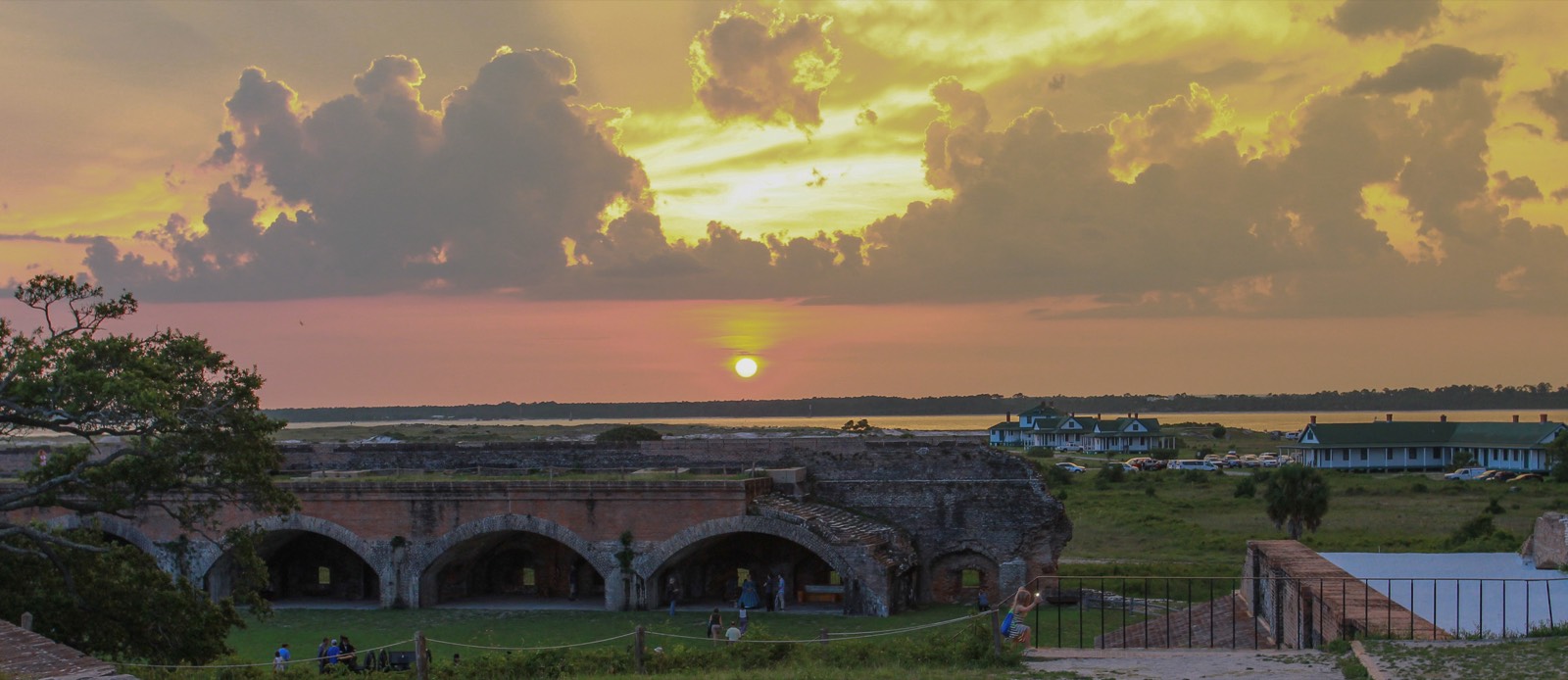
Gulf Islands National Seashore runs 160 miles along the northern Gulf of Mexico, from Cat Island in Mississippi to the eastern end of Santa Rosa Island in the Florida panhandle: barrier islands of white sand, bayous, salt marshes, live oaks and maritime forest, with more than 80 percent of the seashore under water. Over 400 fish species, 300 bird species and a dozen federally listed species live here, and Horn and Petit Bois islands are federally designated wilderness. Hurricanes, storms, sea-level rise and the drift of sand keep the islands moving. [1] [2]
After the War of 1812 the nation chose Pensacola Bay for a navy yard and Third System forts, and the seashore now preserves five such sites, among them Fort Pickens, the largest, begun in 1829 and finished in 1834; Fort Barrancas, which incorporates the eighteenth-century Spanish Bateria de San Antonio; and Fort Massachusetts on Ship Island. Its artillery batteries span the Civil War to the end of World War II. Santa Rosa Island was first protected as a national monument in 1939, and Congress established the national seashore on January 8, 1971. [1] [2]
The Park Service’s own foundation document describes Fort Pickens and Fort Barrancas as monuments to the skill and toil of enslaved masons, carpenters and laborers who built them to protect the liberty of the United States while being denied their own. [2]
Indigenous peoples
In October 1886, after lobbying by influential Pensacola citizens, Geronimo and other Chiricahua and Warm Springs Apache men captured at the end of the Apache Wars were sent to Fort Pickens as prisoners of war, the 2025 historic structures report records. Troops partitioned casemates along the south wall to hold them, and prisoners and guards repaired the fort. From February 1887 the Army let curious civilians into the fort to look at Geronimo. Wives and children joined the men in April 1887; fifteen men, twenty-one women and ten children lived in the fort until the War Department moved them to Mount Vernon Barracks near Mobile in April 1888. An etching on a steel beam in a casemate gallery still reads “ALIVE GERONIMO.” [3]
Black history
Black soldiers served at these posts in the Civil War. Seven companies of the 2nd Louisiana Native Guards, raised among the free men of color of New Orleans in 1862, took station on Ship Island in January 1863, and on April 9, 1863, two companies raided East Pascagoula, Mississippi, making them, the park says, the first Black unit on the Gulf Frontier to meet Confederates in combat; by that summer most if not all of the officers of color had been purged by review boards or asked to resign. In July 1864 the 25th U.S. Colored Troops, about 1,000 men who volunteered at Camp William Penn in Philadelphia, arrived on Pensacola Bay and were split among Forts Pickens, Barrancas and Advanced Redoubt; more than 180 of them died during the war. Under Jim Crow, when Pensacola Beach was whites-only, Black residents went instead to the eastern end of Perdido Key, now Rosamond Johnson Beach. [4] [5] [6]
Slavery
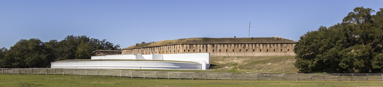
Enslaved men built these forts. For Fort Pickens, engineer William H. Chase relied on the New Orleans firm Underhill and Strong, which owned about 100 enslaved men experienced in fort building, and on others he rented directly from slaveholders; the park says enslaved men also built Fort McRee, Fort Barrancas and part of Advanced Redoubt. Fort Pickens also drew people escaping slavery. On March 12, 1861, eight enslaved people reached Fort Pickens and were sent back; by that summer one or two arrived each day by canoe, skiff or plank and were no longer turned away. Peter Dyson, an enslaved man rented out as a mason in 1851, escaped across the bay with his wife Henrietta in 1861 and reached New York that October. In 2020 Fort Pickens was named to the Underground Railroad Network to Freedom. [7] [8] [3]
Climate & environment
At its peak in 2005, Hurricane Katrina completely submerged the entire Mississippi–Alabama barrier island chain, temporarily cutting several islands apart. The 2016 foundation document reports that sea level has already risen and projects an additional 1.82 to 2.32 feet by 2100, with more intense storms and heat, more erosion and possible saltwater intrusion threatening land and ecosystems; rising seas may inundate many fortification sites, especially Fort Massachusetts and Fort McRee. A 2024 assessment prepared for the Park Service by Western Carolina University found 56 percent of the seashore’s 295 buildings, fortifications, roads and trails highly vulnerable to coastal hazards and sea-level rise. [2] [9]
Japanese American incarceration
In late 1942 the Army selected Nisei soldiers of the 100th Infantry Battalion, Japanese Americans from Hawaii, for a top-secret training mission and sent them to Ship Island. Every day they boated six miles to Cat Island, where Swiss dog trainer William A. Prestre, who believed that Japanese people smell different than Americans, had them hide in the marshes while dogs tracked them. The park’s account explains that dogs tell people apart by diet, not ancestry, so the training failed; that Prestre ordered the Nisei, against their wishes, to hurt the dogs to create aggression; and that injuries were common, though protective gear prevented serious harm. The mission ended after four months and remained hidden for years after the war; the park calls it a brutal mission and a misguided attempt at improving jungle warfare. [10]
Sources
- NPSHistory.com: Gulf Islands National Seashore archive page — overview (from the 2018 NPS brochure) and establishment block
- NPS, Foundation Document, Gulf Islands National Seashore, Florida–Mississippi (June 2016)
- Historic Structures Report: Fort Pickens and Battery Pensacola, Gulf Islands National Seashore (NPS, 2025)
- NPS, 2nd Louisiana Native Guards (nps.gov article, last updated October 29, 2018; drawn from Bearss, Ship Island HRS, 1984)
- NPS, 25th United States Colored Troops: The Sable Sons of Uncle Abe (nps.gov article, last updated December 9, 2019)
- NPS, Gulf Islands NS, Rosamond Johnson (nps.gov, last updated December 4, 2019)
- NPS, Gulf Islands NS, Fort Pickens (nps.gov, last updated March 1, 2022)
- NPS, Peter, Property, and Posterity (nps.gov article, last updated November 14, 2019)
- Peek, Thompson, Tormey & Young, Coastal Hazards & Sea-Level Rise Asset Vulnerability Assessment for Gulf Islands National Seashore: Updated Summary of Results (NPS 635/194634, September 2024)
- NPS, Japanese Americans on Cat Island (nps.gov article, last updated April 14, 2020)
Removed Per Nps Court Filing: 10 exhibit photos, 10 design PDFs, 1 video — 21 total artifacts
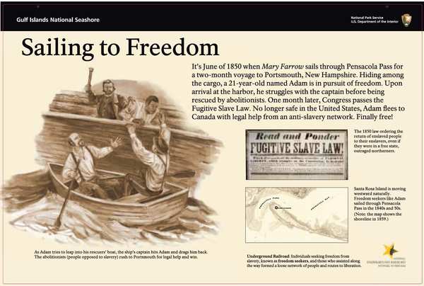
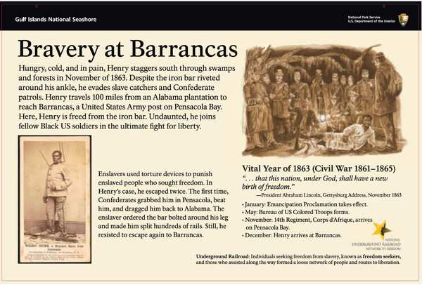
In December 1863, a freedom seeker named Henry crossed Union lines and arrived at Fort Barrancas on Pensacola Bay wearing a heavy metal bar on his right leg. Soon after, he enlisted in the 14th Regiment, Corps d'Afrique, as Henry Stalburt. He was one of hundreds of formerly enslaved men who fled to this fort and took up arms for their own freedom.
Fort Barrancas became a station of the United States Colored Troops — Black soldiers who fought for the Union. In September 1863, the 14th Regiment arrived and engaged Confederate forces in combat. In 2021, the National Park Service officially recognized Fort Barrancas as part of the National Underground Railroad Network to Freedom — honoring it as a place where enslaved people sought and found liberty.
The administration now wants to replace the exhibit text that tells this story. The cost estimate for replacing the waysides alone is $42,234.24 — taxpayer money spent to remove historically accurate content about American soldiers who fought for freedom.
Why this matters: The waysides titled “Destination Liberty,” “Rowing to Freedom,” and “Bravery at Barrancas” tell a story of courage recognized by the NPS's own Underground Railroad program. Removing them would erase the very history that earned Fort Barrancas its designation.
- “Exhibits” — removed per NPS court filing
- Exhibits; reason: Disparages Americans past or living; now: At the park
The administration ordered these exhibits replaced because “the content could be considered disparagingly to certain visitors.” The flagged exhibits cover: “Building the Fort, The Civil War, and United States Color Troops” at Fort Barrancas, “The Islands and Human History” at Davis Bayou, and “Live Oaks and Legends” at Headquarters.
Waysides flagged as potentially “disparaging” include: “Built By Slaves,” “Stormy Night Escape,” “Apache Prisoners,” “Dueling with Confederates,” “Down the Island to Freedom,” “Blacks Join Union Army,” “Fight for Ship Island,” “Destination Liberty,” “Jim Crow and Segregation,” and “South on the Underground Railroad.” Three are specifically ordered to be replaced: Apache Prisoners, Built by Slaves, and Fort of Many Faces.
Two publications that “mention enslaved stories” were flagged as “could be considered disparagingly to certain visitors.”
Explore the Full Map
See all 446 entries across every national park and wildlife refuge.
Open Interactive Map →